

Land Clearing in Maryville, TN
Valley acreage, foothill homesites, and cabin tracts across Blount County – cleared with sinkholes flagged, slopes judged honestly, and the right permit office identified before work starts.
Why Choose Us
Land Clearing: Before & After
What the same ground looks like when the machine leaves.
Example Cut Brush project: overgrown acreage opened up with the ground left covered, not bare
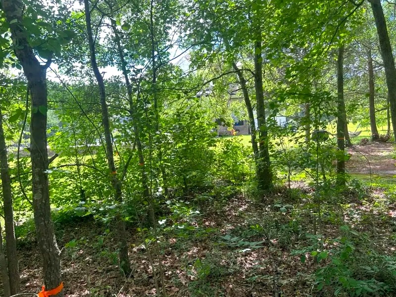
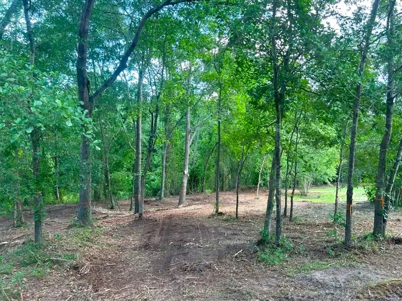
Selective clear from an example project: understory gone, the worthwhile trees still in place
Land Clearing in Maryville: Valley Floors to Foothill Slopes
Draw a line along Chilhowee Mountain and Blount County splits in half. On one side, the Ridge-and-Valley floor: limestone-bottomed pasture, fencerows, and old family farmland around Louisville, Friendsville, and the west side of Maryville. On the other, the Smoky Mountain foothills: steep, wooded, cut by the Little River as it drops out of the national park through Townsend and Walland. Land clearing looks different on each side of that line, and a quote that ignores the difference is a quote you should not trust.
Cut Brush clears homesites, acreage, cabin tracts, and reclaiming pasture across the Maryville area, with equipment and methods chosen for whichever half of the county your deed happens to sit in. With listing prices for Blount County land running a median around $34,218 per acre, every overgrown parcel here is carrying real value under the briars.
Where the Work Happens
- Valley acreagePasture reclamation, fencerow resets, and full-parcel clears on the rolling limestone ground where sinkhole awareness matters more than slope.
- Foothill homesitesBuilding spots, drives, and view corridors opened on wooded grades near Walland and Townsend, with the canopy that gives the place its character deliberately left standing.
- Pre-sale parcelsLand a buyer can actually walk shows its acreage instead of hiding it, which matters at Blount County listing prices.
- Build-prep tractsClearing scoped to the erosion plan and the grading contractor's needs, so the site is ready the day the dirt crew shows up.
The method underneath most of this work is mulch-in-place: a tracked machine grinds standing vegetation into a ground layer as it moves, which keeps soil intact on karst, keeps cover on grades, and leaves nothing behind that needs a burn permit or a dump truck. Where a project genuinely needs bare, gradable dirt, we scope that finish explicitly and sequence it with the required erosion controls instead of improvising.
Sinkholes Are a Clearing Question Here
The valleys of Blount County sit on some of East Tennessee's best-developed karst, part of a limestone corridor stretching roughly 400 miles from Alabama to Virginia. A county inventory spanning 2003 to 2023 turned up 1,080 surface depressions, and 415 of them qualify as structural sinkholes. None of that stops a clearing project, but it should shape one: we flag suspect depressions during the walk-through, keep machine weight off them, and favor mulch-in-place methods that never open the soil, which lines up with the karst-specific stormwater design guidance TDEC publishes for exactly this terrain. If your project later involves grading, that guidance follows the dirt work too.
Maryville's Permit Bar Is Lower Than the State's
Most Tennessee landowners know the state's construction stormwater permit kicks in at one disturbed acre. Fewer know that inside Maryville city limits the bar sits far lower: the city Engineering Department, (865) 273-3500, requires a permit before any land disturbing activity, and it will not release a grading permit on the larger jobs until the TDEC Notice of Coverage, SWPPP, and NOI are all on file. Alcoa runs its own stormwater program through Development Services at (865) 380-4730, and unincorporated parcels answer to Blount County Stormwater at 865-273-5756. Three offices, three sets of paperwork, one question we settle for you at quote time: whose rules is your parcel under?
Straight Answers About Steep Ground
County zoning flags slope formally, lots averaging over 15 percent grade need topographic maps at 5-foot contours and a slope analysis before setbacks are fixed, and the machine flags it physically. Tracked mulchers handle honest foothill grades; they do not belong on every pitch a Chilhowee-side parcel can offer. Our policy is simple: if part of your land is too steep for equipment to work safely, we say so at the walk-through and quote only what can be cleared responsibly. Nobody gets a number for work that should never be attempted.
From the Airport Corridor to the Park Boundary
Demand here is not theoretical. Alcoa has added nearly a quarter to its population since 2020, Smith & Wesson's 650,000-square-foot headquarters opened near McGhee Tyson in late 2023, and TDOT is spending roughly $300 million rebuilding Alcoa Highway to six lanes. Meanwhile the tourist stream through Townsend keeps rising and the community's lack of sewer keeps its land in large wooded pieces rather than dense strips. Whether your clearing project serves a new home, a cabin, a pasture, or a sale, the timing argument is the same: the county is filling in around your parcel either way.
How Land Clearing Works
Three steps from overgrown to usable, with a written number before any machine moves.
Read the Parcel
We walk the ground with you, note grades, depressions, keeper trees, and access, identify which permit office your land answers to, and send a written quote, typically inside a day.
Clear to the Terrain
Valley ground and foothill ground get different plans. Tracked equipment mulches in place where it can, works selectively where it should, and stays off anything unsafe.
Hand Over Usable Land
A final walk together confirms the result: open, covered ground with every flagged feature respected and no debris pile left smoking in the corner.
Why Property Owners Choose Cut Brush
The right machine for the ground, straight answers on the rules, and land you can use when we leave.
Karst-Aware Operations
Depressions get flagged and skirted, not driven over. On ground with 415 documented structural sinkholes countywide, that habit is not optional.
Grade Honesty
Foothill slopes get an on-site judgment call, and unsafe pitches get declined in writing rather than attempted for the invoice.
Right Office, First Call
Maryville Engineering, Alcoa Development Services, and county Stormwater administer different areas. We help identify the likely jurisdiction so the owner can confirm the applicable rules before work is scheduled.
View Without the Scalp
Foothill property is bought for its setting. We open sightlines and building spots while the framing canopy stays.
Debris Becomes Ground Cover
Mulched vegetation stays as a protective mat, so there is no pile to permit, no smoke, and no haul-off line on the bill.
One Written Number
The quote comes from walking your land, covers the agreed scope completely, and does not sprout surprises mid-job.
Get a Free Land Clearing Quote
Describe the parcel, get a real number, decide on your own time. Want the ranges first? Start with the Maryville, TN pricing guide.
Request a Free QuoteRelated Services
If the project is bigger than land clearing, the rest of our clearing work covers the Maryville Area too.


Land Clearing Across the Maryville Area
We provide land clearing in these Blount County and foothills communities.
Land Clearing FAQ
Ready to Put Your Land Back to Work?
Free written quotes for land clearing anywhere in Maryville & Blount County.
Get Your Free Land Clearing QuoteOr call us directly: (919) 525-3950